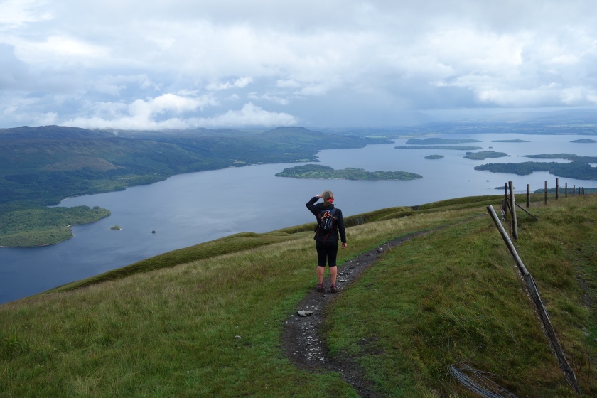
I recently ran or ‘fastpacked’ the Loch Lomond and Cowal Way and even when running it, felt that it deserved more of a telling than a simple post on Facebook. So this is the story of my wee adventure which gives a ‘warts and all’ insight into how I approached it and hopefully it may assist or even inspire others to have a go at the Way in whichever way suits them.
There is no right or wrong way and it’s not about speed. It’s all about getting out there, doing something and creating experiences and memories.
The Loch Lomond and Cowal Way is a long distance footpath which starts at Portavadie on Loch Fyne and ends at Inveruglas on Loch Lomond.
It was established in 2000 as the Cowal Way and the name was changed in 2018 to reflect that, as well as traversing the Cowal Peninsula, it also passes through and ends in the Loch Lomond and Trossachs National Park.

Now one of Scotland’s Great Trails it is waymarked throughout and is a mixture of existing footpaths, tracks, minor roads and traditional rights of way, as it winds it’s way eastward for 57 miles from Portavadie, through Tighnabruaich, Glendaruel, Strachur, Lochgoilhead, Arrochar and finally via Glen Loin to Inveruglas.
The route is undulating at times and one short section at Loch Riddon after Tighnabruaich is surprisingly rough and scrambly but it is never difficult.
Between Lochgoilhead and Arrochar there is a steep climb to the high point at 500 m and although white poles mark the route onwards, careful navigation would be required in misty conditions.
Apart from that short section, navigation via the waymarking signs is straightforward. Throughout, the views are stunning with coastal scenery, forests, hills, lochs and farmland.
The official guide book suggests that the route could be walked in about five days and is subdivided accordingly. However, as an ultra runner I have had my eye on the route as a two day run or fastpack and possibly even as a supported one day run.
As a two day self-sufficient run, I first looked at running and staying at a B&B but never really explored it too much and in the end I opted to carry ultra lightweight camping gear and fastpack the route over two days and one night.
What is ‘Fastpacking’ ?
Fastpacking is the point where ultra light backpacking meets long distance trail running and gives the ability to run long distances across any kind of terrain carrying everything needed for the run and an overnight stay. This means that beautiful, more remote countryside can be accessed without retraints.
Waking up, way off the beaten track is a wonderful experience. Obviously, weight of gear is an issue and a balance has to be struck between carrying enough to be safe, against being able to move fast with the load.
Experience and the knowledge of how to use the kit is paramount. I’ve seen a few people saying that around 7 kilos is an optimum weight but if conditions allow even lighter is possible.
A lightweight tent or shelter is essential and in Scotland in summer more often than not serves to escape from midges rather than the weather.
Next a lightweight sleeping bag and appropriate clothing including waterproofs and warm layer.
Then the decisions start …. a stove? i.e hot food or no hot food or horror of horrors no coffee first thing in the morning ! Do you carry a small quality camera or rely on your mobile phone’s camera? …. Hmmm !
No brainers for me are my midge jacket and mitts providing a total barrier and relief and my PLB or Personal Locator Beacon.
Once the preserve of yachtsmen, modern PLBs are tiny but can summon help in a life or limb emergency. At the press of a button, official emergency services know that the beacon registered to me has been activated and help is sent anywhere in the world.
Priceless and for me, having paid £200 for a unit that will last seven years, it is reassurance. Now I would find it very galling to be lying somewhere, helpless with a broken leg, with no means of summoning help, for the sake of £200.
There are other variations such as satellite phones and other communications devices such as SPOT, which can help when no mobile phone signal is available. I don’t even notice the weight in my bag.
Carrying 7 kilos and trying to run does impact upon your speed but think more of loping all day like a wolf, than running fast for short periods like a cheetah.
Using your inner wolf, you can cover a surprising amount of ground, trotting the flats and downhills and power marching up the hills.
My rucksack weighed around 5 kilos before food and water and contained everything I needed as a bare minimum to survive one nights camping and two days running.
This increased to 7 kilos by the time food and water was added but I still hoped to supplement the food en route.
Obviously I was using water from streams but I had a Sawyer Mini water filter too which I used most times. This protects me from bacteria and other nasties.
The Adventure Starts
A window of opportunity arose in June 2019 with promised settled weather and at 0707 hours on a Tuesday morning I boarded the Citylink Glasgow to Campbeltown bus at Balloch and arrived at Tarbert, Loch Fyne just over two hours later after a relaxing stress free journey with someone else driving.
An added bonus was that with my National Entitlement Card my fare was free. I love the fact that they give you a ticket marked “zero”.
The plan was to get the ferry to Portavadie and then run the route to Inveruglas over two days, camping in the middle and catch a bus home.
To be honest this was all a bit ad hoc and last minute and I had not over-planned and was quite relaxed about the whole thing. I did not have a copy of the guidebook but read internet versions and had the maps of the full route saved and available offline on my phone.
I don’t normally travel, particularly on high ground, without paper maps but I have a good knowledge of the route from Lochgoilhead, having been in all parts of the route there on many occasions.
Thus I was confident of finding my way in the bits that I knew. With the exception of the bit around Tighnabruaich, the rest was ‘terra incognita’ to me but being relatively low lying and with a very favourable weather forecast, I figured I could get by with the waymarking and e’maps.
A quick word on nomenclature, particularly for distances. As a confused child born in the late 50s but growing up in the 60s, I transitioned through imperial measures and metric.
Currently my whole day is measured in miles and my pace in miles per minute. However, when I navigate and talk about mountain heights and climbs, I do so in kilometres and meters because that that is how the map is. So even through I’m thinking of running 30 miles in a day, when I describe a section measured from the map, I’m in kilometres.
Confused …. try being me and don’t start me about cooking when even in the same recipe I can be weighing out ounces and then grams ! I could have standardised it for the blog but it’s more the real me this way.
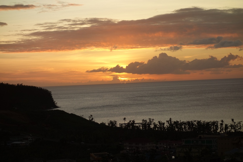
 Tarbert, Loch Fyne.
Tarbert is a pretty village, popular with tourists, set around a fishing harbour which is now an important yachting harbour and marina too.
Tarbert hosts a number of regattas throughout the year and facilities have grown to service this and there are a number of good restaurants, bars and shops. A castle used by Robert the Bruce sits picturesquely above the town.
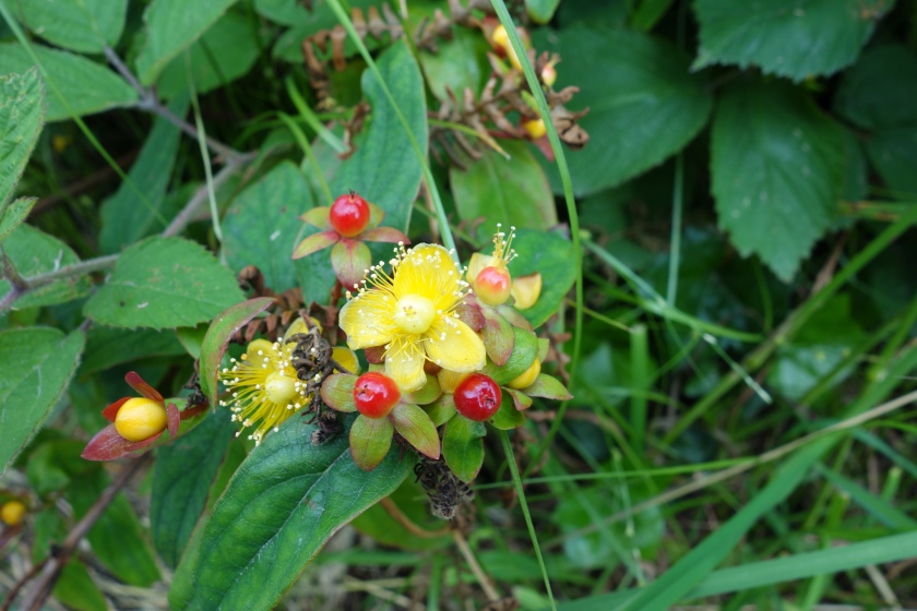 Hypericum aka Rose of Sharon or St John’s Wort growing wild at Tarbert
Portavadie on the east side of Loch Fyne opposite Tarbert was established to build concrete oil platforms for the North Sea but was overtaken by technology as steel platforms emerged and never saw production.
The enclosed port is now used by Portavadie Marina and as well as a yacht marina it has a luxury holiday complex with a variety of accommodation types, restaurants and a luxury spa.
A ferry terminal operated by Caledonian MacBrayne connects to Tarbert and at 1015 hours I embarked on the MV Isle of Cumbrae for the short crossing. As well as cars and cyclists there were a number of pedestrians, clearly local and excitedly heading for a spa day.
 MV Isle of Cumbrae with Papa Smurf waiting patiently
About half way across I noticed a disturbance in the water ahead on the port side of the ship and was excited to see a pod of about four or five harbour porpoises swimming parallel towards us.
They have a very distinctive and unmistakable rolling motion as their heads break the surface briefly and roll forward and down. Unlike dolphins they do not leap out of the water but nevertheless are a common sight nowadays in the Clyde.
It always feels like even more of an adventure when a boat trip is involved.
 Porpoises honestly !
 Portavadie
Day 1 – Portavadie to Tighnabruaich
On arrival at Portavadie I should have stopped to look around but was keen to get started and headed eastward, initially on the concrete road but very quickly turned left onto a track marked with the Loch Lomond and Cowal Way logo.

I quickly gained height and the scenery was stunning looking over a small lochan to Loch Fyne with Arran in the distance to my left.
 Looking over Loch Fyne on first climb
 Small lochan
 Arran in the distance
 Wild orchid
I then passed Ascog Loch and the ruins of Ascog Castle which was originally built in the 15th century by the Lamont clan but destroyed by the Campbells in 1646 after a siege and the defenders were slaughtered after surrendering, which seems a tad unsporting.
 Ascog Loch
 Ascog Castle
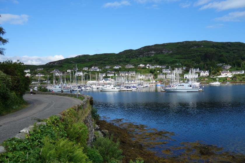
A short spell on a minor road followed passing Milhouse and then I crossed a field then a golf course as the way continued over and down to Kames and Tighnabruaich with stunning views over the Kyles of Bute and the Island of Bute.
 Tighnabruaich and the Kyles of Bute
Kames and Tighnabruaich have a few hotels, shops and restaurants and I had a lovely coffee and scone and then bought some food in the local shop which I ate as I trotted past the moored yachts and the RNLI shop, which unusually for me I did not stop at.
 Tighnabruaich looking to West Kyle, Bute on the left
 Wild rose
Day 1 – Tighnabruaich to Glenbranter
The way continued eastwards arriving at Caladh after a steep hill on a track. Caladh is a beautiful enclosed harbour with a small island and lighthouse which is very popular with local boats as an anchorage.
I have been there many times myself and it was a firm favourite of my children when we sailed there. There is a curious anomaly about Caladh in that it is frequently referred to, even by people who should know better, as Caladh Harbour.
Since Caladh means ‘harbour’ …. Harbour harbour makes little sense. Catching a bit of 4G I sent a picture to my grown up children.
 Caladh
As the way enters Loch Riddon, the way hugs the shore but enters woods and becomes quite rough with steps up and down and tricky narrow, rocky paths.
There are a number of overhanging rocks and caves and as an ultra runner it is very reminiscent of the tricky sections on the east side of Loch Lomond which are infamous for killing a runners pace and average speed on the Highland Fling and West Highland Way Races.
Indeed, at times it was almost scrambling and very enjoyable except when thinking of the drop in average pace which I quickly dismissed.
There has been a fair bit of ‘engineering’ here with handrails, steps and path work but still sympathetic to the surroundings too.
Not overly difficult, just tricky and slow but still enjoyable and with great views over Loch Riddon and the East Kyle of Bute.
 Loch Riddon and East Kyle
As it was low tide, the head of the loch was dry for a considerable distance and not long before the head of the loch, the path emerged onto a minor road.
On leaving the minor road a couple of kilometres later, I joined the main A8003 for another couple of k before going onto a minor road for a while going through Glendaruel.
The main road was fine and not too busy and with room at the side to keep moving even in the face of oncoming traffic.
The minor road went on a bit longer than I normally prefer on hard stuff but to be fair was very quiet in terms of traffic and there was always something to see.
The Glendaruel Hotel was a magnificent looking building but currently not being used and I continued on the minor road at the next junction, turning left onto the West Glen Road recrossing the river by a Telford bridge.
Eventually I came to a fork in the road in front of the historic Lucknow Gates which are said to commemorate the 1857 Siege of Lucknow, India. I carried on to the left with the right path leading to the Glendaruel Camping and Caravan Park and shop.
 Lucknow Gates
The minor road continued for another few kilometres before the way turns right and follows the main road the A886 south for a short distance before turning left at Garvie Farm.
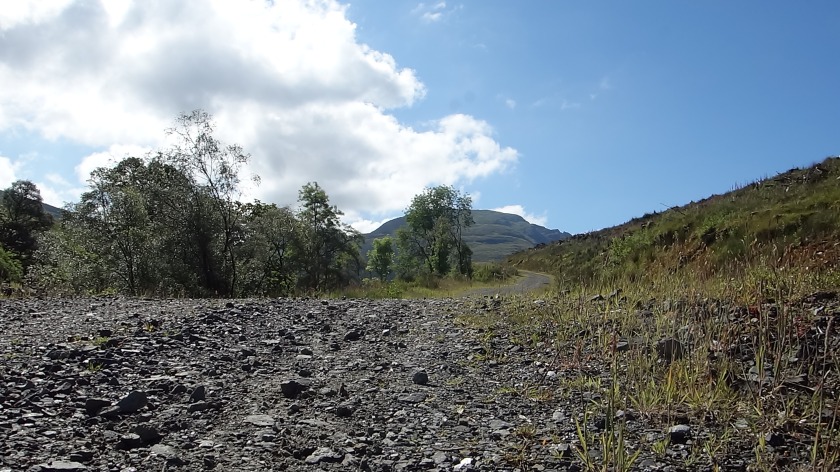
I then continued onto a land rover track rising gradually up, on the way to Glen Branter, passing through a large area of forestry plantation.
A pleasant path led constantly up, reaching a height of around 350 metres and by this time I was beginning to get weary and longing for a suitable camping spot.
 Track towards Glenbranter
I never had a fixed agenda of how far I would go on day one but around 1900 ish hours at the point where I passed 26.2 miles; marathon distance and moving into ultra-marathon territory, my shoulders were stiff and sore and by now I was only trotting the downhills and was marching the flats as well as the ups.
To be fair I was walking at around 15 minute mile pace, which is 4 miles per hour which is quite respectable.
However, as I crested a hill and prepared to trot down, there was always that moment anticipating the slight pain in my shoulders which kicked in as I began to trot and my rucksack settled on my shoulders.
I had probably always thought that 30 miles on the first day gave a psychological edge on day 2
As usual in forested areas, wild camping spots were not forthcoming and I was getting no choice in the matter of my mileage, there was simply nowhere to stop.
I forlornly hoped for a camping spot whilst still high up to avoid the midges but to no avail and before long I was trotting steadily downhill on weary legs towards Glenbranter.
I could see on the map that there was a Forestry Commission centre and car park and thought I might get something there.
Just before reaching that, I found an area of older more natural forest with woodland walks with pine needle covered paths and after casting about found a suitable spot near a river and got ready to pitch my tent.
By this time the wind had dropped and I knew it was going to be midge central and it was. Donning my midge jacket, I hurriedly pitched the tent whilst the water was boiling for my pot noodle and coffee.
Tent pitched I dunked my feet in the river whilst the food cooled and then dived into my tent, secured it against blood sucking intruders and settled in for the night.
 Overnight camp, Lazer Competition tent
Day 2 – Glenbranter to Lochgoilhead
I had a comfortable night and a reasonable sleep soothed by the gentle sounds of the river; is there anything better ? I got up around 0700 and could see clouds of ‘Culicoides impunctatus’ waiting for breakfast !
Ha ha not this time foul fiends and on went the midge jacket again. To the midges consternation I ate my porridge and drank my coffee from inside my midge jacket and they were impotent !
 Midge jacket
I quickly packed and was away by eight and shortly after arrived at the forestry centre which was in full sunlight with no midges.
I relaxed at a picnic table, caught up with messages relaxing in the sun and had a quick wash in the toilets before setting off much refreshed.
About 4 k of minor road with no traffic took me past a school and to the edge of Strachur but I turned off to the right before the village on another minor road past the shinty field before hitting forest tracks.
 Hills above Strachur
 No football here, this is shinty country
Strachur is famous as being the home of Sir Fitzroy MacLean who latterly ran a hotel here. Believed to be partly the inspiration for James Bond, MacLean was aristocratic, a diplomat in Russia who resigned to become a politician as the only means of joining the army at the outbreak of World War 2.
He enlisted as a private and rose through the ranks to Brigadier, one of only two people to do so (the other being Enoch Powell). He was promoted to Major-General after the war. He was a founder member of the SAS and had some amazing exploits.
MacLean is possibly best known for being parachuted behind enemy lines in Yugoslavia under the direct orders of Churchill to liaise with Marshall Tito which he did successfully, living rough with Tito and his partisans.
His life was a mixture of Richard Hannay, Bulldog Drummond and James Bond and reads like something out of a boys adventure book.
A Scot to be proud of and a fascinating character and indeed someone to learn more about and I am trying to order a copy of his book “Eastern Approaches”.
The forest track rose quickly then turned left before petering out and becoming a narrow path leading to the beautiful Curra Lochain nestled between Beinn Lochain 703m and Beinn Bheula 779m.
 Forest track looking ahead uphill
 The road ahead to the right of the hill in the centre
 Looking back towards track from Strachur
 Curra Lochain
 Curra Lochain
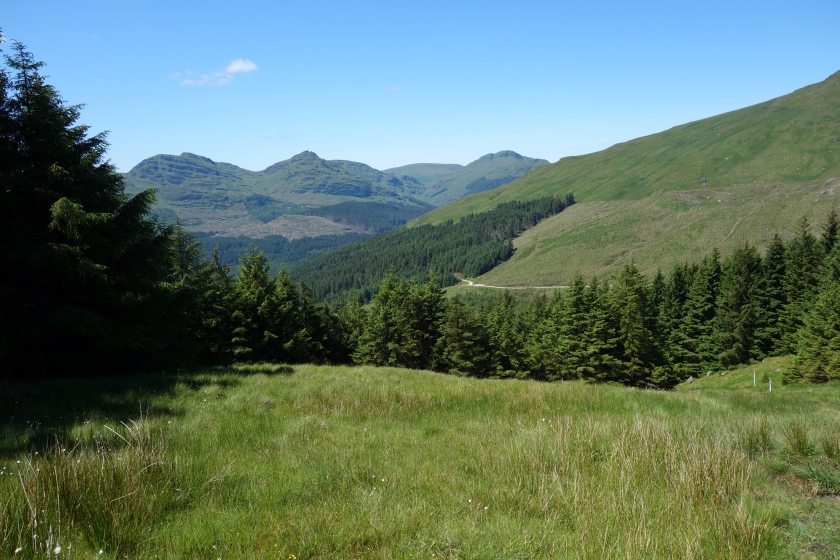
Just after the Lochain there was a sign giving a choice of carrying on the main route or diverging to Struth Ban waterfall I followed the main route on a narrow grassy path for a short while then emerged onto wide forestry tracks.
There were now stunning views down to Lochgoilhead and beyond including to the Cobbler at Arrochar which still looked impossibly far away and I had to go past it.
 Looking down to Lochgoilhead. The Cobbler just to right of the tree just off centre
I could also see up to the waterfall which was pretty spectacular too.
 Struth Ban waterfall
I followed a diversion due to felling and came to a curious bridge with a metal frame over it. As I crossed, I noticed some inviting pools to my right and as it was now quite hot, I succumbed to the temptation of a skinny dip which was very cold but bliss.
Rest assured I had checked as far as I could see for walkers and kept my shorts close.
 Skinny dip pool
Invigorated, I carried on trotting down the forestry roads to Lochgoilhead at sea level again.
The holiday complex of Drymsynie was looking really nice in the sunshine and I stopped in the village shop for a can of full fat, ice cold coke and some food which I consumed overlooking the head of the loch.
 Lochgoilhead looking east
 Lochgoilhead looking west
Day 2 – Lochgoilhead to Ardgartan
Further refreshed, I started the big climb to the highest point of the whole way.
It was a mixed blessing; being totally familiar with the route from now on, balanced against the fact that I knew what was coming for my weary legs, having to climb from sea level to 500 m before descending to sea level again at Ardgartan en route to Arrochar.
The good track climbs steadily but pleasantly upwards into a forest and over a river before getting steeper. The path turns right and a clear gap emerges through the trees leading straight up.
 The start of the steep climb. It is steeper than this looks
 Bench looking back west
The path has been slightly improved over the years and is now clear and obvious but still a narrow proper hill path which would sap the energy of fresh legs.
Oh well, onwards and upwards with some tactical photograph stops and eventually I reached and crossed a fence onto open hillside.
 Looking back west
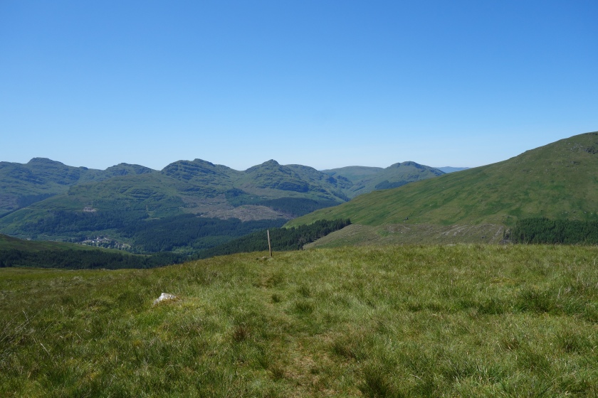
The faint grassy path leads uphill following a line of white posts which have been there well before the Cowal Way and leads to a beallach between The Brack at 787m and Cnoc Coinnich at 761m.
In mist, careful navigation, even with the poles, would be required but for me it was crystal clear with blue skies and I took lots of photographs and a panorama video.
Stunning and such a joy and privilege to be there, able to do things like this.
 Emerging on open hillside looking back west
 Looking north the Brack with the Cobbler behind
 Looking east, Ben Lomond
 Looking west from the pass
A quick romp down led to the forest and a steep descent into Coilessan Glen and I was able to trot steadily downhill to Coilessan where I joined the road that leads to Ardgartan on Loch Long.
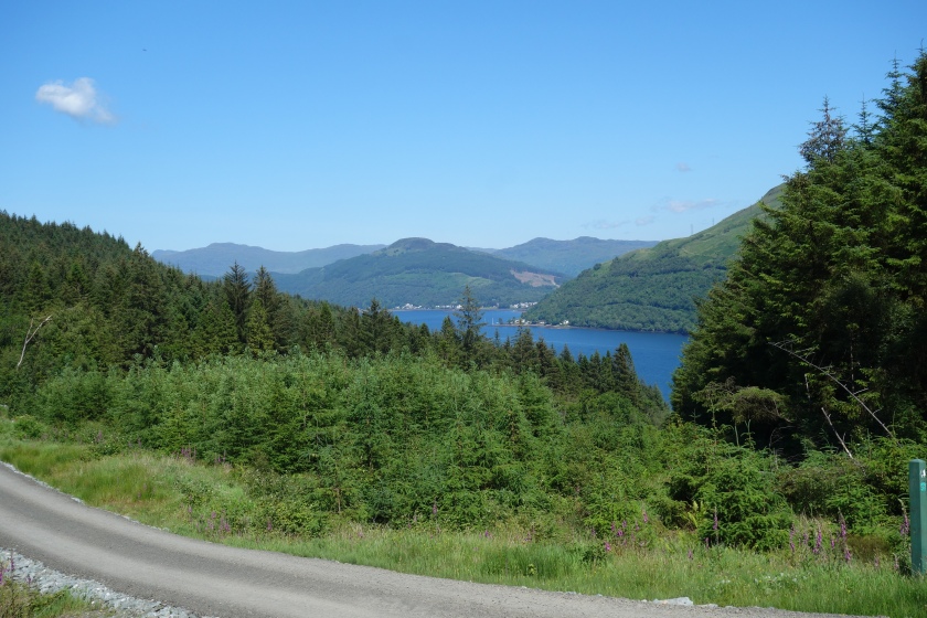 Loch Long from Coilessan
Day 2 – Ardgartan to Inveruglas
The road surface felt hard but made for easy trotting and I passed the car park and crossed the A83 for the first time and ran up to the track that runs parallel to Loch Long and and then down the stony track to the climbers car park at Arrochar.
Before starting the final leg along Glen Loin to Coiregrogan and Inverulglas my brain was screaming for another ice cold coke but the garage and café next door were shut.
I didn’t fancy going further into the village and finding more closed shops, so I shouldered my pack and crossed the A83 for the second time and started to make my way along Glen Loin.
Glen Loin is another lovely glen and I run on it a lot and have been coming here for over 40 years so it is very familiar. It also doubles as the final part of the The Three Lochs Way another lovely route.
 Glen Loin the last climb
By this time I had been mentally writing off the 1759 bus from Inveruglas but realised if I pushed on a wee bit, I might make it, which would mean getting home an hour earlier and more importantly getting into the hot bath that bore my name, so I pushed on a wee bit !
The final steep hill up and over and down towards Coiregrogain wasn’t too bad and as I hit the metalled road that services Loch Sloy dam and power station, I realised that I really could catch that bus.
Fortunately it was downhill on a road but I was hitting a good pace after two full days running with a pack and I was quite pleased with myself as I arrived at Inveruglas with ten minutes to spare.
 Ben Lomond and the end is in sight

Conclusions
Job done and soon I was sitting on the bus reflecting on a great wee adventure. Strava says I did 58.5 miles and 8330 feet of ascent and around 9 hours the first day and nearly 10 the second.
Moving time was around 7 hours each day but I was in no hurry and stopped as and when I wanted. It wasn’t always easy maintaining a pace with the heavier than normal pack but again, I was pleased that I had ran just about all the bits I should have and power marched very well when that was what was required.
Bearing in mind I had free bus travel, my adventure was very cheap but even if paying for fares it would still be a relatively cheap adventure and one that I totally recommend.
In short, the Loch Lomond and Cowal Way is a thoroughly enjoyable, challenging and scenic route and whether fastpacked as I did or walked in sections or continuously in as many days as desired, it would make a great trip.
More luxury could of course be utilised and paid for, including a stay at Portavadie or at some of the many hotels and bed and breakfast establishments. You pays your money and makes your choice but I like the freedom of wild camping and especially waking up in the wilds.
The route is well maintained and waymarked and easy to follow and although there are are some lengthy periods on minor roads, that doesn’t spoil it.
To put things further into perspective; for every mile ran or walked, I ascended 142 feet which compares with a figure of around 145 for the much longer West Highland Way, so a similar height profile relatively.
This emphasises to me that the Loch Lomond and Cowal Way is a worthy long distance trail that deserves respect but would be achieveable with a moderate level of fitness.
Fastpacking the route in three days might have been a bit more relaxed but then I would need to have carried more food so the weight would have gone up and the benefits may be eroded, so two was probably right.
Those who know me may not be surprised that I am beginning to canvass friends to join me in running it all as a one day ultra.
All we need is a driver or two who can carry supplies and meet us every now and again and the pack would be much lighter.
Hmmmm ……..
.


")
 holding tank clean water")


")


")


![DSC_0015[1]](https://i0.wp.com/matthewgemmellblog.wordpress.com/wp-content/uploads/2018/10/dsc_00151.jpg?w=451&h=254&ssl=1 "DSC_0015[1]")